Sykes Lane, Keighley Road and Woodside Road face major development as eight sites are earmarked for 580 new homes
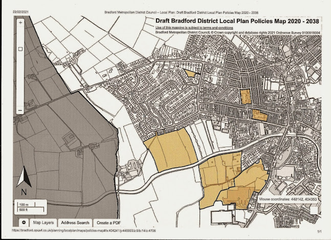
Historic Sykes Lane stands to be obliterated if revised allocations of land for housing go ahead. The large sand-coloured areas on the above map represent sites for 447 new homes. The map is bisected by the Leeds-Liverpool canal. Above the canal are the Woodside Road fields, where 146 homes could be built. Immediately below the canal is the land either side of Sykes Lane, earmarked for 145 houses. Adjoining that area is the Keighley Road site, consisting of the former Riverside Works factory car park and other associated land (156 houses). The five smaller allocations are: North Dene Road (43 homes); Bolton Road/Brown Bank Lane (40 houses); Aire View School in Elliott Street (21 dwellings); Hothfield Street School (22 houses); and Dradishaw Road (7 homes).The Slingsby family are among the users of the nine smallholdings and pens in Sykes Lane who will have to move if the site is developed. Allen Slingsby, who breeds cob horses, is pictured above with his wife Jenny, their daughter Leah (right) and two-year-old son Tommy, who is seated on Woody, a 12-year-old cob. With them is family friend Olivia McRink.

Sykes Lane has been home to pen-holders for as long as anyone can remember. It was also the home of the town's first recreation ground, opened in 1914, before the park was created in 1934. Records indicate Sykes Lane was in existence by 1565 and legend holds that it once was the only route into Silsden from the Steeton side of the River Aire.
Recent research by Dave Mason, who chairs the Silsden Local History Group, shows Sykes Lane on the Silsden settlement map of 1757; at its farthest extent the lane reached to Syke Close, a group of water meadows near the river. The word 'syke' in the Scots language is a small stream, rill or watercourse that crosses flat or boggy ground. Mr Mason says the lane was named after the syke-like marshy water meadows into which it led from the village. The canal-side Banks development by Harron Homes has robbed the adjoining stretch of Sykes Lane (pictured above) of its solitude and charm. The new allocation, if it goes ahead, will turn the whole area either side of the lane beyond The Banks into a huge housing estate.
These fields beyond the pens between the lane and the canal will be lost to housing if Bradford district council's draft Local Plan is adopted. The government has obliged all councils to identify land to meet projected housing demand.
The target for Silsden is 700 new homes between the years 2020 and 2038. After allowing for development already in the pipeline, the council has now identified three brownfield sites and five greenfield sites which could accommodate the remaining 580 homes to meet its target for Silsden.The Keighley Road allocation, partly viewed above looking towards The Banks estate, is earmarked for 156 homes. Silsden's first textile mill was near this section of the site, which for years included a woodyard.
Work is already under way at the Keighley Road site, pictured above from Sykes Lane, looking towards the sports ground.
The Woodside Road site, accommodating146 homes, consists of three agricultural fields by the canal. The picture above shows part of the site. The council says that a bird survey will be required and that sensitive design and layout will be required to mitigate "landscape impacts".


